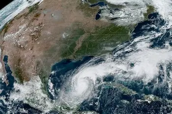
Cyclonic activity in both ocean basins reflects a pattern of high activity this season.
Hurricane Milton raised alarms in Mexico due to its rapid evolution, going from a tropical storm to a Category 5 hurricane on the Saffir-Simpson scale in less than 24 hours, the first of this magnitude to directly hit our country.
According to forecasts from the National Meteorological Service (SMN), a total of between 35 and 41 tropical cyclones are expected for the 2024 hurricane season in both basins: Pacific and Atlantic, regardless of their category.
Of that total, scientific models predict that in the Pacific, three to four major hurricanes (Category 3, 4, or 5) will form in 2024, while in the Atlantic, there could be four to five.
From May until October 8, two major hurricanes have been recorded in the Pacific Ocean: Gilma, which reached Category 4 in August, and John, which evolved to Category 3.
In the Atlantic, with Milton, there are now four major cyclones: Beryl, Helene, Kirk, and Milton, two of which made landfall on the Yucatán Peninsula. Matt Dominick shared an impressive time-lapse of the cyclone passing by Yucatán on social media.
It is important to note that it is not possible to precisely predict the strength each cyclone will reach, but scientists point out that high sea surface temperatures favor the formation of major tropical cyclones.
This year serves as a transition between the El Niño phenomenon (higher temperatures in the Pacific) and La Niña (warmer waters in the Atlantic), so between seven and nine hurricanes that could exceed Category 3 are expected in both basins.
Milton Continues Its Advance After Causing Damage in Yucatán
Milton regained Category 5 status and continues to affect the Yucatán Peninsula with intense rains and strong winds, reported the National Meteorological Service (SMN).
This meteorological phenomenon, part of the current tropical cyclone season, has generated rains of between 75 and 150 millimeters, winds with gusts of up to 200 km/h, and waves of 6 to 8 meters in height in the region. Additionally, the possible formation of waterspouts in Yucatán is expected, while in Campeche and Quintana Roo, very heavy rains and winds of up to 90 km/h are anticipated.
In the Atlantic Ocean, the cyclone season has seen the formation of six new systems in the past two weeks: Helene, Isaac, Joyce, Kirk, Leslie, and the aforementioned Milton. With these, the total number of phenomena in this basin rises to 13, out of the 20 to 23 systems forecasted for the current cycle.
“These flights collect critical data that help improve forecasts”
On the other hand, in the Pacific Ocean, the system known as John has resurfaced, adding to the 10 cyclones already formed out of the 15 to 18 predicted for the season. This phenomenon stands out for being the second time it has developed in the region during the same cycle.
Cyclonic activity in both ocean basins reflects a pattern of high activity this season, leading authorities to maintain a constant state of alert to mitigate the adverse effects of these natural phenomena.
Source: Infobae


