The update from yesterday, Thursday, October 10, 2024, from the Climate Prediction Center shows the continuity of the neutral phase, but with increasingly lower temperatures of -0.5 °C on the sea surface of the equatorial Pacific, increasing the reserve of “cold” in the depths; the thermal anomaly in region 3.4 was -0.4 °C, almost at the time of La Niña becoming official.
There are several “methods” for measuring sea surface temperature (SST) and its anomalies (SSTA). The one used by NOAA is called OISSTv2.1, but it was changed to UK Met OSTIA, which unfortunately alters the information, which is why La Niña has not yet become official.
In the neutral phase, as its name suggests, the weather conditions can be neutralized in Mexico, making it less likely that extreme events will occur frequently, such as with El Niño (record heat, fires, drought) or with La Niña (record droughts and cyclones, as well as rain).
Others, such as Coral Reef Watch, show an anomaly of -0.5 °C and CDAS of -0.8 °C, both indicating a weak Niña, but changing to a moderate one in the coming weeks. In this case, we have to go with the official version, which indicates a Neutral phase.
Intensity probabilities
Few changes have been observed in the last month, but now there is a tendency towards lower intensity and probability of occurrence, oscillating between the Neutral and La Niña transition. In the September-November quarter, there is a 60% chance that La Niña will arrive this fall, but increasing to 75% in the middle of winter, although briefly ending in the spring of 2025.
Official ENSO probabilities
The forecast remains that La Niña will arrive this winter with a 75% chance, ending in spring; periods of extreme Arctic heat and cold with occasional rain will be latent.
It is difficult to be sure, but for next year, we could be in a neutral phase from spring to summer, and then there is uncertainty if this phase continues or even El Niño returns, but we must wait about 3-5 months to know if in Mexico we will have a 2025 with rain and coolness or drought and heat.
Neutral phase, a great help
It is true that every time the waters of the equatorial Pacific are regulated, being within the normal range related to the neutral phase, the meteorological conditions at a global level do not show an exact or outstanding pattern as when there is Niño or Niña, since a little bit of everything can occur and of any intensity.
However, it is very likely that, at the time when it is present, they will regulate to typical conditions: if it is autumn, the fronts combine with tropical systems, alternating rain, cold and dryness; if it is winter, the cold is normalized with important periods, even of rain, but being mostly dry, because that is the classic winter in Mexico.
Precipitation anomaly in December 2024.
In general, rain may be scarce, being more likely over the Gulf Coast and part of the center and southeast; in addition to frost, if there is precipitation with cold, snowfall would occur.
If it is spring, the heat will not be extreme, alternating with polar masses, storms, hail and coolness and, if it is summer, the rains will increase, with the impact of tropical cyclones and a cooler environment. With this, I have already resolved the question of, what will happen in winter if we remain in a neutral phase?
Meteorological trend for this winter 2024-2025
In general, there could be a season with temperatures within or above normal from December to February and with precipitation within or below normal. Under drier conditions, temperatures can be more extreme and we are already seeing this these days with dry air that generates very cold dawns.
From November, changes can be accentuated towards thermal contrasts with sunny and generally mild days, to others with wind, periods of clouds, some rain and a marked thermal drop; this month there may be periods of heavy rain in the Gulf and southeast, being very occasional in the Altiplano.
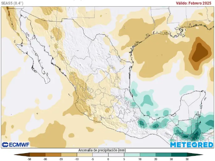
Precipitation anomaly for February 2025.
Currently, from December to January, there are possible more frequent rains in the north, northeast, center, east and southeast (not including the Bajío) with normal or higher than usual anomalies due to cold fronts, troughs and eventual DANAs and/or jet streams, increasing the potential for snowfall.
The outlook for February looks similar to the previous months, with more rain concentrated on the Gulf Coast and southeast of Mexico due to cold fronts and troughs. The first storms with hail may be generated…
Temperatures will continue to present extreme events, some hot vs. others very cold, with ice, wind and snow. Between neutral phases and La Niña, frosts tend to be more frequent, when dense fogs form in the Sierra Madre Oriental and central mountains, freezing the droplets in the forests, becoming covered with ice.
Typical extreme events
If the neutral phase continues, any winter situation would be latent, and it would not be unusual to have an extreme event of snowfall, ice and cold like in 2013-2014. Do you even remember the last snowfall in Mexico City? This occurred in January 1967, when neutrality was present, there was no Niño or Niña.
If La Niña establishes itself, it would not be unusual to go from a day with 30 °C to another with 0 °C raining or snowing, or simply for the cold to be extreme with severe and long-lasting frosts like in January 2008 and February 2011. La Niña likes to send cold to North America on the days around Christmas and Valentine’s Day (statistically).
Source: meteored


