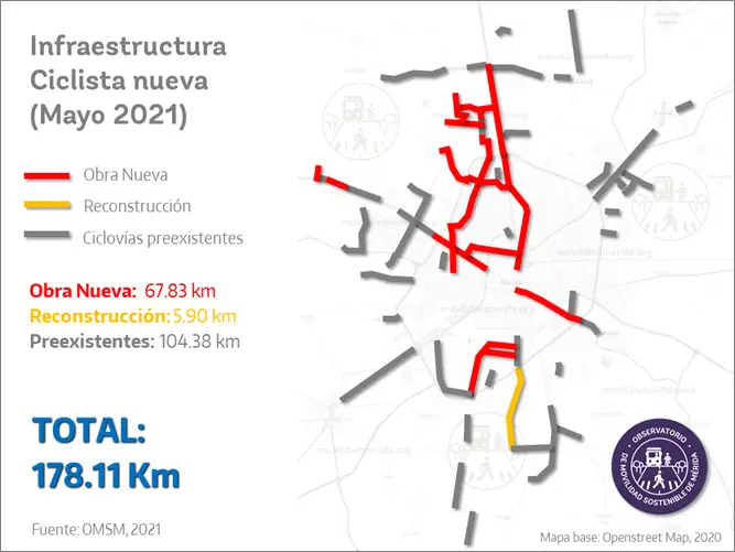
Mérida, Yucatán, has set an example in sustainable urban mobility by promoting the use of bicycles through its extensive network of bike paths. The Mérida Yucatán Bike Path Map is a valuable tool that simplifies navigation and encourages a healthier lifestyle.
What does the Mérida Yucatán Bike Path Map include?
The map features well-defined routes that crisscross different parts of the city, connecting historic sites to modern areas. These paths prioritize cyclist safety and comfort, making it easy for users to explore the city’s beauty while enjoying a pleasant ride.
Benefits of Bike Paths
Bike paths not only provide an alternative mode of transportation but also contribute to reducing traffic congestion and pollution in the city. As part of the New Mobility Projects in Yucatan, Mérida aims to integrate various modes of transportation, such as buses and bicycles, to create a more accessible urban space.
Experiences for Tourists
For tourists visiting Mérida, using the Bike Path Map is an excellent way to discover both famous landmarks and hidden gems. The map also includes information on nearby attractions, making it easier to plan an itinerary that suits your interests.
Fares and Schedules of Buses in Merida
To enhance mobility, users can combine bicycle trips with public transportation by consulting the Fares and Schedules of Buses in Merida. This allows for greater flexibility and efficiency in travel planning.
New Mobility Projects in Yucatan
The implementation of the Mérida Yucatán Bike Path Map is part of a broader effort to improve transportation infrastructure in the region. The New Mobility Projects in Yucatan aim to integrate bicycles as a viable option not only for leisure but also for daily commutes, contributing to a more sustainable and environmentally friendly urban environment.
Source: La Chispa


