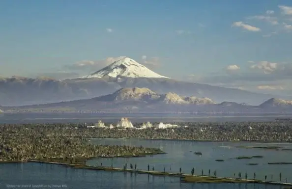
Mexico-Tenochtitlan, the great city of the Mexica, celebrates its 700th anniversary in 2025. What is now Mexico City was built on an island in a lake, thanks to a complex water system that harnessed the water for agriculture and reduced flooding.
Previously, only the descriptions of the city in Hernán Cortés’s “Cartas de Relación” and his maps, as well as the chronicle of Bernal Díaz del Castillo, allowed us to visualize, through imagination, what the current capital of Mexico, with its four main roads and thousands of canals, looked like before the arrival of the Spanish.
In 2023, Dutchman Thomas Kole, fascinated by these descriptions of the city, created, using digital tools, a “3D reconstruction of the Mexica capital.” Never in 500 years had images been created that so clearly represent Mexico-Tenochtitlan. Kole led a project called “Portrait of Tenochtitlan,” which was published after a year and a half of work. Drawing on historical and archaeological sources, he set out to “bring Tenochtitlan back to life as faithfully as possible.”
Kole, a native of the Netherlands, told BBC Mundo that he began the project out of curiosity, having read about the subject. “I thought maybe I could use technology to visualize it, first for myself, and then maybe for others,” he said.
Mexico-Tenochtitlan was one of the largest cities in the world at its time. It housed more than 200,000 inhabitants engaged in a wide range of activities, from trade and agriculture to religion and warfare. It also received tribute from approximately 5 million people.
“The most difficult part (of doing the modeling) was not having good maps from that time. The Mexica likely had detailed maps of their city.” (…) But they no longer exist; they were lost or burned, probably during the conquest,” Kole explained to BBC Mundo.
“You have to reconstruct from more recent material: dozens of years after the conquest if you’re lucky, hundreds if not. That’s all there is to work with,” he noted. Another difficulty is that many sources contradict each other, and he had to find a way to reconcile them.
Kole explained that his work focused only on Tenochtitlan and Tlatelolco due to their greater number of sources; although he acknowledges that more cities existed in the surrounding area, as the Valley of Mexico had an urban system with nearly 50 cities.
“It would be interesting to see reconstructions of other cities, such as Iztapalapa or Texcoco, which would be fascinating historical sites. But there is even less information about them,” Kole said.
The Pre-Hispanic Relationship with Water
The Mexica and other surrounding groups had extensive knowledge of how to use and manage water and built a complex water system that was later lost.
This allowed them to access drinking water, transported in aqueducts; prevent and reduce flooding through a system of canals, dikes, and irrigation ditches; and use the lagoons to transport goods that would otherwise have been more costly and time-consuming.
At Lake Texcoco, they created an extensive barrier of earth and stone to separate the salt waters of Chalco and the fresh waters of Xochimilco. This dam was known as the Albarradón de Nezahualcóyotl—named after the tlatoani who conceived it after a flood—in Iztapalapa. Additionally, the Mexica used a system of agriculture on chinampas, a type of farming island, which had been used since the Early Postclassic period (900-1200 AD) by the peoples of the lake basin. Chinampa agriculture is one of the few pre-Hispanic techniques that still survive south of Mexico City, especially in the Xochimilco area.

Source: proceso


