This Friday, cold front 42 and the air mass driving it are moving over eastern Mexico. Along the way, they will encounter a pair of surface troughs (low-pressure channels), one located along the center and south, and another located from the southeast to the Yucatan Peninsula.
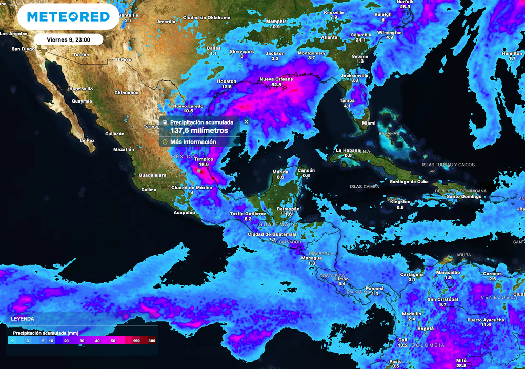
Thanks to the aforementioned atmospheric phenomena and the arrival of moisture from the Gulf of Mexico, downpours with very heavy rains, accompanied by thunderstorms and hail, are expected mainly over areas in the northeast, east, center, south, and southeast of the country.
During the meteorological spring, the rise in ambient temperatures provides enough energy to form unexpected thunderstorms and the possible fall of hail.
Accumulated rainfall during the course of the day could include very heavy rainfall of 75 mm (3 inches) with intense rainfall of up to 150 mm (5.9 inches) over the next 12 hours in the states of Hidalgo, Puebla, southern Tamaulipas, Veracruz, Oaxaca, Chiapas, and Tabasco, becoming more significant in the afternoon and evening. Be alert for possible flash flooding.
In addition, there will be heavy rainfall of 50 mm (2 inches) with very heavy rainfall of up to 74 mm (2.9 inches) in Nuevo León, northern Tamaulipas, San Luis Potosí, Querétaro, Tlaxcala, and Campeche, and downpours of up to 25 mm (1 inch) with heavy rainfall of 50 mm (2 inches) in the State of Mexico, Mexico City, Morelos, Yucatán, and Quintana Roo.
Storms and Rain in Mexico
The presence of rain over much of Mexico will leave significant accumulations that could reach 150 mm (5.9 inches), mainly in the eastern states. Remember to take extreme precautions due to possible flash flooding.
Air mass cools the atmosphere in some states
The dominance of cold air driven by the frontal system is also causing cooling temperatures over the north, northeast, east, center, and southeast of Mexico, as well as a “norte” effect with gusts of 60 to 80 km/h on the coasts and areas of the states of Tamaulipas and Veracruz.
These conditions are expected to extend throughout Saturday from the state of Tabasco to the Isthmus and Gulf of Tehuantepec in Oaxaca.
Western Mexico will also see significant rainfall.
On the other hand, a trough will influence the Sierra Madre Occidental, which, combined with moisture from the Pacific Ocean, will also cause rain and thunderstorms over some areas of the Northern Mesa and western Mexico.
Regarding accumulated rainfall in these regions, isolated rainfall of up to 5 mm is expected in Sonora, Chihuahua, Durango, Aguascalientes, and Jalisco; Showers of 6 to 25 mm (0.24 to 1.00 in) in Coahuila, Zacatecas, Guanajuato, and Michoacán, and sometimes heavy downpours of 50 mm (2 in) in Guerrero.
Let’s not forget the heat.
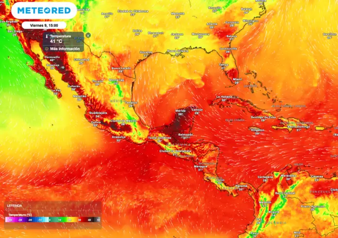
Despite the cooling, a typical spring weather pattern continues. The dominance of an anticyclone in the mid-levels of the atmosphere extending over western and central Mexico, maintaining a warm to very hot environment in the northwestern, western, and southern states of Mexico.
Maximum temperatures of 40°C (104°F) are expected in Baja California, Sonora, Chihuahua, Durango, Sinaloa, Nayarit, Jalisco, Colima, Michoacán, Guerrero, Morelos, Puebla, Tabasco, Campeche, and Yucatán. Temperatures range from 35 to 39°C (95 to 103°F) in Baja California Sur, Zacatecas, Aguascalientes, Guanajuato, the State of Mexico, Veracruz, Oaxaca, Chiapas, and Quintana Roo, and from 30 to 34°C (86 to 94°F) in Querétaro and San Luis Potosí (southwest).
This circumstance maintains a warm to hot environment in areas of Jalisco, Colima, Michoacán, Guerrero, and Oaxaca, a condition that will extend to the states of Nayarit, Sinaloa, Durango, and Chihuahua. It’s worth mentioning that the hottest temperatures will be in coastal and jungle areas between 11 a.m. and 4 p.m.
Maximum Temperature in Mexico
Maximum temperatures are expected to reach and even exceed 40°C (104°F) in some areas of Mexico, especially in the northwestern states. Typical spring conditions.
Today’s recommendations:
Check your weather forecast. During the warm season, health can be affected by heat waves, causing physical effects such as dehydration, heat exhaustion, or dizziness. Remember to stay hydrated and avoid going outdoors between 11 a.m. and 4 p.m.
If you detect the presence of a thunderstorm, move to a safe place such as a dry room. Avoid being under trees, on sports fields, near bodies of water, or in swimming pools, as these types of places are often prone to lightning strikes.
Remember to be alert to wind intensity, as a strong gust can put you at risk from falling objects or being thrown as projectiles. The formation of whirlwinds, dust devils, and tornadoes is common. If you find yourself outside during one of these phenomena, seek shelter immediately in a safe place.

Source: meteored


