Tropical Storm Erick has formed in the Pacific Ocean off the coast of Chiapas, becoming the fifth named hurricane system of the 2025 hurricane season in the basin.
Its development follows the recent passages of Alvin, Barbara, Cosme, and Dalila, in a season that the National Meteorological Service (SMN) has described as more active than usual, with greater impact on Mexico’s Pacific coast.
Erick is currently moving west-northwest, parallel to the coast of Chiapas, generating adverse weather conditions for the southeast of the country.
Meteorological authorities have issued warnings for heavy rains, significant wind gusts, and high waves, especially in the states of Chiapas and Oaxaca.
Where is it currently located?
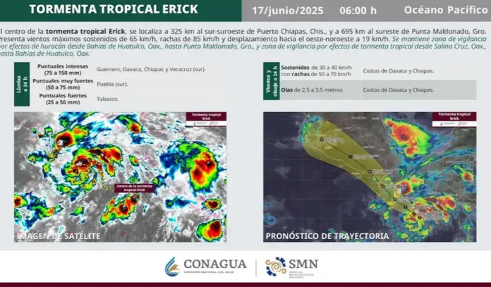
At 6:00 a.m. on Tuesday, June 17, the center of the system was located 325 kilometers south-southwest of Puerto Chiapas, Chiapas, and 695 kilometers southeast of Punta Maldonado, Guerrero.
Erick is packing maximum sustained winds of 65 kilometers per hour and gusts of up to 85 km/h, with a minimum central pressure of 1005 hPa. It is moving at a speed of 19 km/h (12 mph) in a west-northwesterly direction (300°).
The system maintains a broad circulation, which has caused intense rainfall (between 75 and 150 mm) in Guerrero, Oaxaca, Chiapas, and southern Veracruz.
This rainfall could be accompanied by lightning and hail, in addition to causing rising river and stream levels, landslides, puddles, and flooding in low-lying areas.
Coastal Impact Alert
According to the National Meteorological Service (SMN), a hurricane watch has been established from Bahías de Huatulco, Oaxaca, to Punta Maldonado, Guerrero.
A tropical storm watch is also in effect from Salina Cruz to Bahías de Huatulco, on the Oaxacan coast.
Navigators should exercise extreme caution due to waves between 2.5 and 3.5 meters, as well as sustained winds of between 30 and 40 km/h (19 and 25 mph) and gusts of up to 70 km/h (43 mph).
These weather conditions will gradually intensify starting Tuesday, as the system continues to move parallel to the country’s southern coast.
How many hurricanes and tropical storms are expected during the 2025 season?
According to the official forecast presented by the National Water Commission (Conagua), between 16 and 20 tropical cyclones are expected to form in the Pacific during the current season—which began on May 15 and will run until November 30—of which up to six major hurricanes are expected (categories 3, 4, or 5 on the Saffir-Simpson scale).
In comparison, between 13 and 17 named systems are projected in the Atlantic.
Mexico, in a cyclone vulnerability zone
During a conference, the National Civil Protection Coordination (CNPC) emphasized that Mexico is one of the countries most exposed to tropical cyclones due to its geographical location, with coasts on both oceans.
In the last 61 years alone, the states with the highest incidence of impacts are Baja California Sur (13.8%), Quintana Roo (13%), Sinaloa (10.5%), and Veracruz (9.3%).
The head of the National Meteorological Service (SMN), Fabián Vázquez Romaña, explained that the current climate context is influenced by a neutral phase of the ENSO (El Niño–Southern Oscillation) phenomenon, which could favor more persistent rainfall in the north of the country and an increase in the formation of cyclones.
“Conditions are ripe for an active season, especially in the Pacific. It is important not to underestimate any system and heed official warnings,” he noted.
What should be done when a cyclone approaches?
The CNPC reiterated the preventive measures to be taken in the event of a tropical cyclone approaching national coasts:
Identify temporary shelters and evacuation routes.
Prepare a first aid kit and important documents.
Unplug electrical appliances and turn off gas and water valves.
Stay away from windows, poles, and trees.
Listen to the news or use battery-powered radios for instructions.
It also emphasized the importance of avoiding spreading rumors or unverified information, as misinformation can generate unnecessary panic.
“All validated information will be available on the official platforms of the Government of Mexico. We invite citizens and the media to consult only those sources,” reiterated the SMN.
Active season: a constant alert
The 2025 cyclone season has already passed the first four formations in the Pacific, and with Erick, it is approaching one of the two expected peaks of greatest activity: August and September.
Throughout this phase, tropical systems are expected to increase in frequency and intensity, so authorities have implemented coordinated emergency response and risk mitigation plans.
The National Meteorological Service (SMN) is maintaining constant monitoring of Erick’s path and behavior, as other low-pressure zones begin to develop in the region.
The list of names for the 2025 Pacific season includes, in addition to those already in use, the following: Flossie, Gil, Henriette, Ivo, Juliette, Kiko, and Lorena.
Those that cause serious damage may be removed from the list and replaced in subsequent years, as was the case with Otis and Dora.
Source: milenio


