

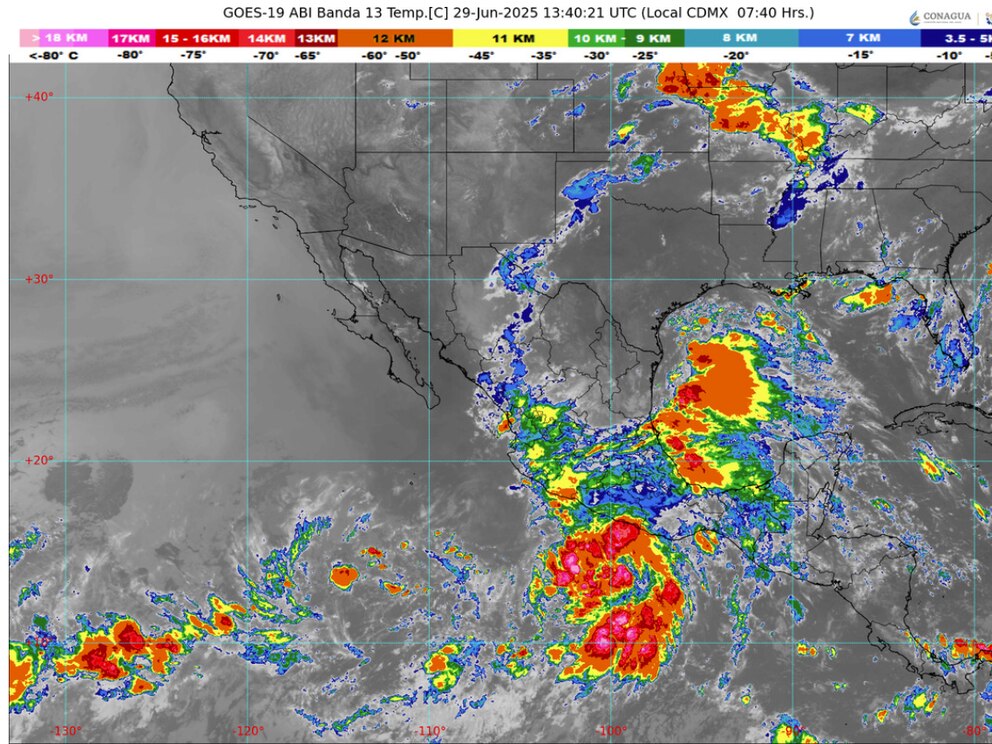
This Sunday, Tropical Depression Two (Barry, named by the U.S. National Hurricane Center (NHC)) will strengthen into a tropical storm in the southwestern Gulf of Mexico and is expected to make landfall around 7:00 PM this afternoon near Tamaulipas. Heavy to intense rain conditions will continue in northeastern, eastern, and southeastern Mexico, with torrential rains in central and southern Tamaulipas, northern and eastern Puebla, and northern and central Veracruz.
Winds of 50 to 60 km/h (31 to 37 mph) with gusts of 70 to 90 km/h (43 to 55 mph) and waves of 3 to 4 meters (1.6 to 1.7 in) are forecast for the coasts of central and southern Tamaulipas and northern and central Veracruz. Simultaneously, Tropical Depression Six-E (named Flossie by the NHC) will move south of Oaxaca and Guerrero. Its circulation will cause very heavy to intense rains in the west and south of the country. Heavy rains are forecast in Guerrero (coast and north) and Oaxaca (north, center, and coast), as well as wind gusts of 60 to 80 km/h and waves of 3 to 4 meters high on the coasts of both states. Finally, low-pressure channels will develop over the interior of Mexico, combined with a cyclonic circulation at high levels over northeastern Mexico, along with the influx of moisture and atmospheric instability, will cause showers and heavy to very heavy rains, accompanied by lightning, in the north, center, and west of the country. Heavy rains are forecast in the State of Mexico (southwest), Morelos, and Chiapas (west and south).
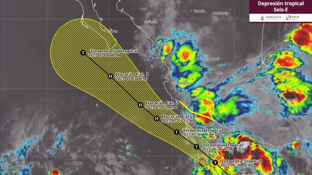
At 3:00 a.m. Central Mexico Time, Tropical Depression Six-E formed. It is located 435 kilometers (km) south of Acapulco and 385 km (240 mi) south-southwest of Punta Maldonado, both in Guerrero, with maximum sustained winds of 45 kilometers per hour (km/h), gusts of 65 km/h (40 mph), and moving northwest at 19 km/h (12 mph).
The system’s cloud bands, combined with the moisture it generates, will cause heavy rains (75 to 150 millimeters [mm]) in Michoacán (northeast, east, and south), Guerrero (coast and north), and Oaxaca (north, center, and coast); Very strong (50 to 75 mm) in Jalisco and Colima, as well as winds of 40 to 50 km/h (25 to 31 mph) with gusts of 60 to 80 km/h (37 to 50 mph) and waves of 2.5 to 3.5 meters (8 to 11 ft) along the coasts of Guerrero and Oaxaca.
In the next 24 hours, Tropical Storm Flossie is expected to intensify, moving parallel to the coasts of Guerrero, Michoacán, and Colima, and will be closest to the coast of Mexico (Jalisco) on Tuesday.
The National Meteorological Service (SMN) of the National Water Commission (Conagua), in coordination with the National Hurricane Center of the United States of America, has established a storm warning zone from Zihuatanejo, Guerrero, to Manzanillo, Colima.
At the same time, in the Atlantic Ocean, Tropical Depression Two was located 85 km north-northeast of Veracruz, Veracruz, and 200 km southeast of Tuxpan, Veracruz, with maximum sustained winds of 55 km/h (34 mph), gusts of 75 km/h (45 mph), and moving west-northwest at 15 km/h (9 mph). This system maintains the forecast for torrential rains (150 to 250 mm) in Tamaulipas (central and southern), Puebla (northern and eastern), and Veracruz (central and northern); intense rains (75 to 150 mm) in San Luis Potosí (eastern), Hidalgo (eastern), and Tabasco.
Winds of 50 to 60 km/h (31 to 37 mph) with gusts of 70 to 90 km/h (44 to 56 mph) are forecast, with waves of 2 to 3 m (6 to 10 ft) along the coasts of central and southern Veracruz.
The aforementioned rainfall could cause landslides, rising river and stream levels, as well as overflows and flooding in low-lying areas of the aforementioned states. Therefore, the public is urged to heed the warnings issued by the National Meteorological Service (SMN) and follow the recommendations of Civil Protection.
Rainfall forecast for today, June 29, 2025:
Heavy rain with torrential rainfall (150 to 250 mm): Tamaulipas (central and south), Puebla (north and east), and Veracruz (central and north).
Very heavy rain with intense rainfall (75 to 150 mm): San Luis Potosí (east), Hidalgo (east), Guerrero (coast and north), Oaxaca (north, center, and coast), Chiapas (west and south), Michoacán (northeast, east, and south), State of Mexico (southwest), Morelos, and Tabasco.
Heavy rain with very heavy rainfall (50 to 75 mm): Nayarit, Jalisco, Colima, Querétaro, and Tlaxcala.
Showers with heavy rainfall (25 to 50 mm): Chihuahua, Durango, Sinaloa, and Mexico City.
Shower intervals (5 to 25 mm): Sonora, Coahuila, Nuevo León, Zacatecas, Guanajuato, Campeche, Yucatán, and Quintana Roo.
Scattered showers (0.1 to 5 mm): Baja California Sur and Aguascalientes.
Heavy to torrential rains could raise river and stream levels, causing ponding, landslides, and flooding.
Strong wind gusts could cause trees and billboards to fall.
High temperature forecast for today, June 29, 2025:
High temperatures above 45°C: Baja California (northeast), Sonora, and Sinaloa (north).
High temperatures of 40 to 45°C: Baja California Sur, Chihuahua (northeast and southwest), and Durango (west).
Maximum temperatures of 35 to 40°C: Coahuila, Nuevo León, Tamaulipas, Nayarit, and Campeche.
Maximum temperatures of 30 to 35°C: Zacatecas (north and south), Jalisco, Colima, Michoacán, Guerrero, Oaxaca, Chiapas, Tabasco, Yucatán, and Quintana Roo.
Wind and wave forecast for today, June 29, 2025:
Winds of 50 to 60 km/h with gusts of 70 to 90 km/h: coasts of Tamaulipas (central and south) and Veracruz (central and north).
Winds of 40 to 50 km/h with gusts of 60 to 80 km/h: coasts of Oaxaca and Guerrero.
Winds of 20 to 30 km/h (12.5 to 18.9 mph) with gusts of 40 to 60 km/h (25 to 37 mph): Chihuahua, Coahuila, Nuevo León, San Luis Potosí, Zacatecas, Tabasco (coast), Campeche, Yucatán, and Quintana Roo; with possible dust storms: Baja California, Baja California Sur, and Sonora.
Waves of 3 to 4 meters high and possible formation of waterspouts: coasts of Tamaulipas (central and southern), Veracruz (central and northern), Oaxaca, and Guerrero.
Forecast by region:
Valley of Mexico: Partly cloudy to cloudy skies throughout the day. Cool weather in the morning; cold weather in mountainous areas, with fog and a chance of isolated rain showers in the region. In the afternoon, mild weather will occur with showers and heavy rain in Mexico City, as well as very heavy to heavy rain in the State of Mexico (southwest). These rains could be accompanied by lightning; they could also cause flooding, mudslides, and rising river and stream levels. Strong wind gusts in storm areas could cause trees and billboards to fall. The minimum temperature for Mexico City will be 13 to 15°C (55 to 59°F) and the maximum temperature will be 21 to 23°C (69 to 73°F). For Toluca, State of Mexico, a minimum temperature of 9 to 11°C (49 to 53°F) and a maximum of 19 to 21°C (67 to 70°F). Northerly winds of 10 to 20 km/h (6 to 12 mph) with gusts up to 40 km/h (25 mph) in storm areas are expected.
Baja California Peninsula: Clear skies in Baja California and partly cloudy with the possibility of scattered showers in Baja California Sur. Mild weather during the morning with fog banks on the western coast of Baja California. During the afternoon, hot weather will be expected in the region and extremely hot in northeastern Baja California. Northwesterly winds of 20 to 30 km/h (12 to 18 mph) with gusts of 40 to 60 km/h (25 to 37 mph) and possible dust storms in the peninsula.
North Pacific: Partly cloudy to cloudy skies with occasional heavy rains in Sinaloa, which could cause rising river and stream levels, landslides, flooding, ponding, and reduced visibility. Showers in Sonora, all with lightning and possible hail. In the morning, mild to warm conditions will occur, with fog in northwestern Sonora. During the afternoon, hot to very hot conditions will occur, as well as extremely hot conditions in central Sonora. Westerly and northwesterly winds of 20 to 30 km/h (12 to 19 mph) will occur in the region, with gusts of 40 to 60 km/h (25 to 37 mph) and possible dust storms in Sonora.
Central Pacific: Partly cloudy to cloudy skies with heavy rains in Michoacán (northeast, east, and south), as well as very heavy rains in Nayarit, Jalisco, and Colima. This could lead to rising river and stream levels, landslides, flooding, puddles, and reduced visibility. Cool conditions in the morning and warm to hot in the afternoon. Winds will fluctuate between 15 and 30 km/h (9 to 18 mph) in the region, with gusts in stormy areas.
South Pacific: Cloudy skies with occasional heavy rains in Guerrero (coast and north), Oaxaca (north, center, and coast), and Chiapas (west and south), which could lead to rising river and stream levels, landslides, flooding, puddles, and reduced visibility. Mild weather in the morning with fog in the mountains. Warm to hot weather in the afternoon. Easterly winds of 40 to 50 km/h (25 to 31 mph) with gusts of 60 to 80 km/h (3 to 13 feet), waves of 3 to 4 meters (10 to 13 feet), and possible formation of waterspouts along the coasts of Oaxaca and Guerrero.
Gulf of Mexico: Cloudy skies during the day, with occasional torrential rains in Tamaulipas (center and south) and Veracruz (center and north), as well as intense rains in Tabasco; All of these events will bring lightning, strong gusts of wind, and possible hail. These events could also cause reduced visibility on stretches of roads, flooding, puddles, and landslides, and rising river and stream levels. Cool conditions with fog banks in the region. During the afternoon, temperatures will be mild to warm. East and northeast winds of 50 to 60 km/h (31 to 37 mph) with gusts of 70 to 90 km/h (43 to 57 mph), waves of 3 to 4 meters (10 to 13 feet), and possible waterspout formation along the coasts of Tamaulipas (central and southern) and Veracruz (central and northern).
Yucatan Peninsula: Cloudy skies for most of the day, with showers and thunderstorms in the region. Mild to warm conditions will occur in the morning, and hot conditions will occur during the afternoon. East winds of 20 to 30 km/h (12 to 18 mph) with gusts of 40 to 60 km/h (25 to 35 mph) on the peninsula.
Source: infobae


