

From the early hours of March 30, 2026, Cold Front 44 entered Mexico from the northwest, driven by a polar trough and a jet stream that extended its reach as far south as the state of Puebla.
This phenomenon, interacting with moisture from the Pacific Ocean, caused a sharp drop in temperature across various regions of the country.
During its initial path, the system generated strong winds in northern states, with high gusts, as well as rain in areas such as Baja California. As it moved toward the center of the country, it encountered atmospheric conditions that intensified its effects, including the formation of dense cloud cover and precipitation.
Snowfall and extreme weather in Mexico due to Cold Front 44
The system’s advance created an unusual scenario for late March, with snow and sleet falling in high mountain areas.
For example, regions like Nevado de Toluca and Jocotitlán Hill recorded snow accumulations, while the Toluca Valley experienced intense hailstorms that covered roads.
These conditions reflect a climatic contrast, where spring-like weather gave way to winter-like characteristics, with temperatures near freezing in various high-altitude areas.
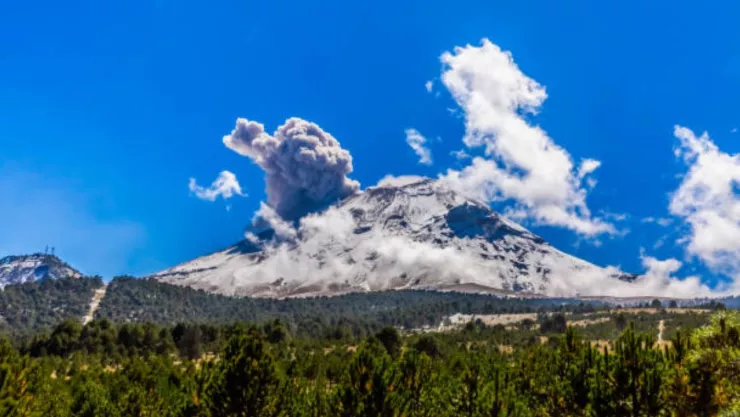
What will be the impact of Cold Front 44 in Puebla?
Cold Front 44 in Puebla has generated notable effects in different regions of the state, especially in volcanic areas like Popocatépetl and Iztaccíhuatl, where a layer of snow was visible from the metropolitan area.
In these areas, temperatures dropped considerably, reaching sub-zero levels in high-altitude locations.
In the Sierra Norte and Nororiental regions, municipalities such as Huauchinango, Xicotepec, and Teziutlán are experiencing dense fog and persistent drizzle, reducing visibility on highways and maintaining a cool atmosphere for much of the day.
Meanwhile, in the central valleys and the city of Puebla, isolated showers accompanied by gusts of wind and possible hail are occurring, altering the usual conditions for this time of year. In contrast, the Mixteca region is experiencing warmer weather, although with cloud cover and isolated light showers.
Finally, this phenomenon has resulted in winter-like landscapes in mountainous areas and abrupt changes in the weather.
The system’s behavior is maintaining atmospheric instability, with effects that continue to influence different regions of the state, creating an unusual weather pattern for this time of year.
Cold Front 28 will hit Puebla with rain and low temperatures.
Source: aztecapuebla


