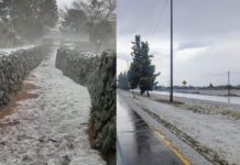
The National Meteorological Service warns of conditions for snow and sleet fall in the high areas of the states of Sinaloa, Sonora, Baja California, Chihuahua and Durango.
The agency dependent on Conagua reported that for today the front No. 28 will extend as stationary over the south of the Yucatan Peninsula and the west of the Caribbean Sea, interacting with instability at high levels of the atmosphere, as well as with the humidity input generated by the subtropical jet stream, causing intense punctual rains in areas of Veracruz and Oaxaca; very strong punctuals in Tamaulipas, Nuevo León, San Luis Potosí, Puebla, Chiapas, Tabasco, Campeche, Yucatán and Quintana Roo and strong punctuals in Sonora and Chihuahua, in addition to showers intervals in Baja California, the Northern Table, south, west and center of the country, including the Valley of Mexico.
Likewise, the conditions for snow, sleet or freezing rain fall in mountain ranges of Baja California, Sonora, Chihuahua, Durango and Sinaloa will continue, as well as in the mountain peaks above 4,200 meters above sea level in the center and east of the Mexican Republic.
Finally, it is expected that the front No. 28 will stop affecting the country by the end of this day, while its arctic air mass will begin to modify its thermal characteristics, allowing a gradual rise in daytime temperatures in the northeast, east, center and southeast of Mexico, maintaining east component wind with gusts of 50 to 70 km/h and high waves of 1 to 3 meters high on the coasts of Veracruz, Isthmus and Gulf of Tehuantepec.
Source: Debate


