

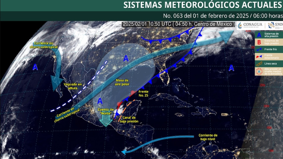
Cold Front No. 25 will remain stationary north of the Yucatan Peninsula, generating adverse weather conditions in various regions of the country.
Its interaction with a low pressure channel in the southeast of Mexico will cause showers and heavy to very heavy rains in this area, as well as in the east of the national territory. According to forecasts, intense rainfall is expected in the states of Tabasco, Veracruz and Chiapas.
Heavy rains with very heavy rains (50 to 75 mm): Oaxaca.
Intervals of showers with heavy rains (25 to 50 mm): Puebla, Campeche and Yucatan.
Intervals of showers (5 to 25 mm): Coahuila, Nuevo León, Zacatecas, San Luis Potosí, Hidalgo, Tlaxcala, State of Mexico and Quintana Roo.
The polar air mass associated with the frontal system will cause a “Norte” event with winds reaching gusts of between 70 and 90 km/h in the Isthmus and Gulf of Tehuantepec. In Veracruz and Tabasco, the gusts will range between 50 and 70 km/h, although the intensity of the wind is expected to gradually decrease during the afternoon.
Temperatures will continue to drop
In addition, this cold air mass will cause a drop in daytime temperatures in the northeast, east, southeast and center of the country, accompanied by fog banks in the east and southeast of the national territory.
On the other hand, a trough in the middle and upper levels of the atmosphere, which extends from the northeast to the west of the country, in combination with the entry of humidity generated by the subtropical jet stream, will favor showers and possible electrical discharges in states of the Northern and Central Tablelands, including the Valley of Mexico and the northeast of the country. Winds with gusts of between 40 and 60 km/h are also expected in the west of the country.
Despite the presence of these meteorological systems, the warm to hot weather will continue in states in the west, south and southeast of the country, mainly in coastal areas, where temperatures will continue to be high.
Weather in the Valley of Mexico
During the morning, partly cloudy skies and fog banks are forecast in the region, cold to cool weather, and very cold (-5 to 0°C) in high areas of the State of Mexico.
In the afternoon, warm to warm weather, partly cloudy to cloudy skies with the probability of isolated rains in Mexico City and intervals of showers in Edomex, said rains may be accompanied by electrical discharges.
Variable direction winds of 10 to 20 km/h with gusts of up to 40 km/h. The minimum temperature for CDMX will be 7 to 9 °C and the maximum 23 to 25 °C. For Toluca, a minimum temperature of 1 to 3 °C and a maximum of 20 to 22 °C is expected.
Authorities urge the population to stay informed through official channels and to take extreme precautions due to the possibility of heavy rains, strong winds and a drop in temperature in the regions affected by Cold Front No. 25.

Source: infobae


