

The first long weekend of the year is approaching and with it the perfect opportunity to do activities outside of the routine, where adventure and nature go hand in hand.
Because Mexico has a great offer of natural destinations, mountaineering, hiking and camping have become a very popular practice for both national and international tourists, and especially at this time of year, when some mountains are dressed in white.
Paso de Cortés. It is an incredible historical and natural point between the Iztaccíhuatl and Popocatépetl volcanoes, located in the State of Mexico and Puebla. It is located approximately 3,600 meters above sea level and is the main access for ascents to Iztaccíhuatl. How to get there? From CDMX: Take the highway to Amecameca and follow the signs to the IztaPopo National Park. From Puebla: Head towards Cholula and then take the highway to San Nicolás de los Ranchos to the park.
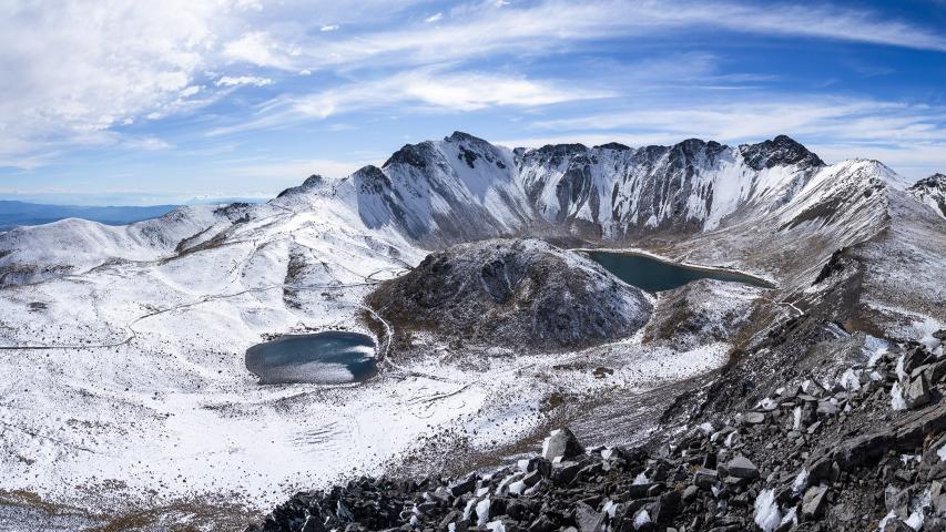
Nevado de Toluca. It is one of the most popular hiking and mountaineering destinations in Mexico. With a height of 4,680 meters above sea level, it is the fourth highest peak in the country and offers impressive landscapes, as well as accessible routes for beginners and challenges for experienced mountaineers. How to get there? It is located in the State of Mexico, about 45 km from Toluca and 2 hours from Mexico City. If you travel by car from Mexico City, take the Mexico-Toluca highway, continue towards Zinacantepec and then towards the Nevado de Toluca National Park.
Pico de Orizaba. Also known as Citlaltépetl (which in Nahuatl means “Star Mountain”), it is the highest mountain in Mexico and the third highest in North America, with an altitude of 5,636 meters above sea level. It is an inactive volcano located between the states of Veracruz and Puebla, and one of the most challenging destinations for mountaineers in the country. How to get there? It is located between Veracruz and Puebla, from Mexico City it is approximately 4-5 hours by car. The most common route is via Tlachichuca (Puebla), where there are hostels and guide services. From Veracruz, you can access it through Ciudad Serdán or Coscomatepec.
La Malinche. Also called Matlalcueye, “the one with blue skirts” in Nahuatl, is the sixth highest peak in Mexico, with 4,420 meters above sea level. It is located between Tlaxcala and Puebla and is one of the best mountains for those looking to get started in high mountains before attempting more challenging peaks such as Iztaccíhuatl or Pico de Orizaba. How to get there? It is located between Tlaxcala and Puebla, in the La Malinche National Park, if you travel from Mexico City it is approximately 2.5 – 3 hours by car.
Tips for the visit
In any case, before starting the adventure it is necessary to take into account the particulars of each place, however, we share with you some tips that will help you have a more pleasant experience
Warm clothing: Temperatures can drop in winter.
Adequate equipment: In addition to warm clothing, and non-smooth shoes, a helmet, headlamp and thick gloves are essential.
Hydration and food: Bring enough water and energy snacks.
Acclimatization: If you are not used to the altitude, go up slowly to avoid altitude sickness.
Guides and logistics: If you are inexperienced, it is best to hire a guide
Respect for the environment: Do not leave trash and follow the marked routes.
Source: eleconomista


