

The extreme heat, low altitude, long roads, and scattered communities are not minor details: they are the material basis that explains why this region of southern Mexico became strategic.
Tierra Caliente is not an administrative entity nor a recent invention. It is a geographic and cultural region that extends mainly through Michoacán, Guerrero, and the State of Mexico, following the Balsas River basin.
Its boundaries are not precise, but there is a basic consensus: it comprises areas below 1,000 meters above sea level, with high temperatures and a predominantly rural population.
Here, the territory not only shapes daily life. It also defines who can live there, who can keep watch, and who can control.
The name says it all. Tierra Caliente is one of the hottest regions in the country. Average annual temperatures range between 30 and 40 degrees Celsius, but in the most extreme months, highs can exceed 50 degrees, especially in municipalities like Huetamo, Zirándaro, and Ciudad Altamirano.
Rainfall is scarce and concentrated. The annual average ranges from 600 to 1,000 millimeters, with only 60 to 80 days of precipitation per year. Outside the rainy season, relative humidity can drop below 25%. There are no frosts in the lower Balsas River basin.
These conditions not only affect agriculture but also make any prolonged state presence costly and physically exhausting. Maintaining constant patrols, lengthy operations, or sustained surveillance in such an environment requires resources that few local institutions possess.
For those familiar with the territory, the heat becomes a natural barrier. It doesn’t prevent access, but it does make it intermittent, uneven, and tiring.
Tierra Caliente doesn’t fit on official maps. It lacks a single government and unified institutional coordination. Its territory is divided among at least three states and dozens of municipalities.
In Guerrero, the region encompasses nine municipalities and an area of 6,667 square kilometers. In Michoacán, the smallest defined area covers 7,343 square kilometers, although broader definitions include up to 16 municipalities. In the State of Mexico, it extends along the southern strip, with an estimated area between 4,000 and 5,000 square kilometers.
In total, the region encompasses around 20,000 square kilometers, traversed by administrative boundaries that shift from state to state.
For the authorities, this means multiple command structures, different budgets, and priorities that don’t always align. For those operating regionally, these boundaries function like cracks.
Moving between states can mean changing jurisdictions without leaving the same geographic area. The territory is continuous; institutional coordination is not.
The geography of Tierra Caliente is dominated by broad valleys, rivers, and rural roads. The terrain is mostly flat in the center, with altitudes between 200 and 300 meters, and peripheral elevations such as Cerro El Gallo, which reaches 1,740 meters.
Rivers like the Balsas and the Cutzamala are not only sources of irrigation; they also function as natural corridors. Around them, trails, secondary roads, and local routes have developed, connecting the Pacific coast with the center of the country.
These are not spectacular or visible routes. They are discreet paths, difficult to monitor permanently, but easy to control locally. In a region where towns are separated by kilometers of rural terrain, any unified response is fragmented.
Control doesn’t happen all at once. It is built section by section, community by community.
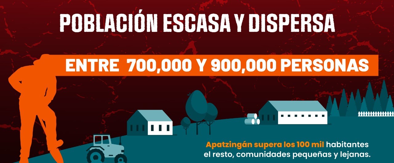
Tierra Caliente is not a densely populated region. In total, it is estimated that between 700,000 and 900,000 people live there, with an average density of only 30 to 40 inhabitants per square kilometer.
In Michoacán, depending on the specific area, the population was around 491,912 in 2014.
Apatzingán, with just over 100,000 inhabitants, is one of the main urban centers, along with Ciudad Altamirano and Tejupilco. The rest are small communities, with long distances and limited services.
This dispersion has direct effects: it hinders collective organization, increases the cost of institutional presence, and facilitates fragmented control.
The territory does not favor rapid responses; it favors persistent presence.
The economy of Tierra Caliente is, above all, agricultural. In Michoacán, more than 1.3 million hectares were planted in 2022, according to the INEGI Agricultural Census. Products such as avocado, melon, corn, sugarcane, watermelon, and beans dominate the landscape.
Source: meganoticias


