

In Mexico, its main effects include a drier-than-usual season and less rainfall in the south-central part of the country, as well as contributing to the formation of more intense hurricanes in the Pacific.
El Niño, a natural pattern that causes anomalies in the surface water temperature of the Pacific, could return with force in the Northern Hemisphere summer of 2026 and remain for the rest of the year, according to the most recent reports from the World Meteorological Organization (WMO). This warning, echoed by other scientific organizations that study the global climate, has fueled a spiral of misinformation, driven by alarmist headlines warning of the arrival of a “super-El Niño,” “the worst in centuries,” or “the Godzilla Niño.”
“When we see very hot or very cold temperatures that go beyond the historical average, that’s when we say that an El Niño or a La Niña event is imminent. We’re really talking about the same phenomenon: cold or warm temperatures in the waters of the equatorial Pacific Ocean that are above the historical average,” explains Christian Domínguez, a meteorologist and researcher at the Institute of Atmospheric Sciences and Climate Change at UNAM (National Autonomous University of Mexico), to this newspaper.
El Niño comprises three phases of the same phenomenon: the neutral phase, a transitional period where conditions in the Pacific are around average; and La Niña, when the Pacific waters cool below the historical average temperature for three months. The activity of this oscillation directly influences wind patterns, rainfall, and climate globally. It also affects heat waves, droughts, and the formation of hurricanes in the Pacific and Atlantic. Hence, this prediction necessitates taking action and “strengthening monitoring along the Mexican Pacific coast, because we have signs that more intense hurricanes could occur,” Domínguez explains.
“Although we are currently in neutral conditions, we are heading toward an El Niño event according to current forecasts, and it is expected to begin forming in April, May, and June and continue until the end of the year,” he asserts, in line with the forecast from the U.S. National Oceanic and Atmospheric Administration (NOAA), which calculates a 61% probability of El Niño forming between May and July, a prediction that increases to 90% if the forecast extends to the end of the year.
Domínguez dismisses the superlatives that have been used to describe the highly probable formation of El Niño this summer—“in 2015 they also called it El Niño Godzilla,” he states—while maintaining that its intensity is still an unknown. “Most models indicate that we will have a warm phase of El Niño; however, the intensity of this phase is where the models could be wrong, precisely because of the months in which the forecast is being made. The phenomena are not yet fully formed, and making a projection of what will happen in the summer or December is difficult,” he shares.
The scientific evidence available to date reveals that one of the most evident effects of El Niño in Mexico is its impact on hurricane season, the period that extends from May to November each year and puts the country’s coasts on alert. While in the Atlantic—Domínguez explains—the El Niño signal usually causes a decrease in the number of tropical cyclones compared to the average, the increase in temperature in the Pacific waters favors the formation of more intense hurricanes during the season.
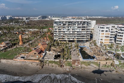
Domínguez cites Patricia (2015) and Otis (2023) as examples, the only two Category 5 hurricanes to have made landfall on Mexico’s Pacific coast, both formed during years of El Niño activity. “There was Patricia in 2015, which reached 330 kilometers per hour; and Otis in 2023, which reached 270 kilometers per hour before making landfall in Acapulco,” he explains.
Beyond the catastrophic potential of hurricanes, El Niño anomalies in the Pacific also influence the amount of rainfall in central and southern Mexico. “Once it forms, during the summer and as we transition to autumn, the signal is that central and southern Mexico will receive less rain than average. It won’t be as rainy a season,” he explains. Domínguez believes that the official formation of El Niño could occur in the summer, right at the beginning of the climatic transition to autumn in the Northern Hemisphere. “We can’t be sure it will last until October, November, or December. That’s part of the uncertainty, but we know it will form and that it has a probability of being intense.”
The expert emphasizes that this phenomenon and its various phases existed long before the study of the climate crisis caused by human activity: “[El Niño] was discovered in 1890, and records exist from before we even talked about climate change. However, what we have seen as a consequence in the last decade is that El Niño usually left a gap of about five or six years between each phase, and now it has given us a rollercoaster ride,” she explains, referring to the disturbances recorded since 2020 that break with the typical classification of NOAA and other organizations, which considered the fluctuations to occur within a period of between two and seven years.
Growing scientific evidence also suggests that the climate crisis plays a key role in the rapid intensification of hurricanes, as happened with Otis in 2023, which went from a tropical storm to a powerful Category 5 hurricane in just 12 hours. “We are living in a hotter world, and one of the effects of the climate crisis is to make the extreme even more extreme. If El Niño is known to cause more intense hurricanes, then these will be even more intense than in previous decades, and the same goes for the lack of rainfall. These are all phenomena that existed before, but now, with the climate crisis, they are becoming increasingly extreme, and we must be prepared,” he concludes.
Source: elpais


