‘John’ was downgraded to a tropical storm on Tuesday, September 24, after making landfall on Monday as a Category 3 hurricane in Guerrero, where it remains, the National Meteorological Service (SMN) reported.
“‘John’ remains on land over Guerrero as a tropical storm,” the SMN warned, adding that it will cause intense to extraordinary rains, strong winds and high waves in the south and southeast of the national territory.
It warned that John’s cloud bands will increase the probability of showers to heavy rains in the center of the country, including the Valley of Mexico.
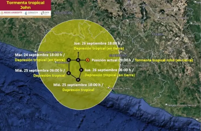
It detailed that the tropical storm is located 70 kilometers east-northeast of Tecpan de Galeana, in Guerrero, and 110 kilometers northwest of Acapulco.
“A prevention zone for tropical storm effects remains from Punta Maldonado to Zihuatanejo, Guerrero,” the SMN reported.
Where will it rain this Tuesday due to tropical storm ‘John’?
According to the SMN weather forecast, extraordinary rainfall is expected in Guerrero and Oaxaca; torrential rainfall in Chiapas; and intense rainfall in Michoacán, Puebla, Tabasco and Veracruz.
In addition, the cloud bands of ‘John’ will increase the probability of showers to heavy rainfall in the center of the country, including the Valley of Mexico.
“At the same time, strong gusts of wind, high waves and possible formation of waterspouts are expected on the coasts of Guerrero, Oaxaca and Chiapas,” said the SMN.
What will happen with ‘John’ in the next 48 hours?
The SMN indicated that it expects that around 6:00 p.m., ‘John’ will be degraded to a tropical depression on land over Guerrero, 50 kilometers east of Zihuatanejo, and 75 kilometers northwest of Tecpan de Galeana, in the same state.
By Wednesday morning, it is expected to remain a tropical depression with sustained winds of 55 to 75 kilometers per hour. It will be located 50 kilometers west-northwest of Tecpan de Galeana, and 60 kilometers southeast of Zihuatanejo.
At 6:00 p.m. on Wednesday, it will remain under the same conditions, however, the SMN predicts that by Thursday morning, September 26, it will be located on land 25 km north-northwest of Tecpan de Galeana, and 95 km east-southeast of Zihuatanejo.
By Thursday afternoon, ‘John’ will continue to be a tropical depression and will remain over land 60 km north-northwest of Tecpan de Galeana, and 80 km east of Zihuatanejo.
The location of tropical storm ‘John’ in Guerrero, where it will remain until Thursday. (Pelaez Pavon Lizbeth Berenice)
How many hurricanes have hit Mexico this season?
The phenomenon made landfall in one of the poorest areas of the country and which almost a year ago, on October 25, suffered the onslaught of Hurricane ‘Otis’, which broke the record for the intensification of a cyclone in the Mexican Pacific.
The phenomenon was surprising because at first the SMN only predicted that it would be a tropical storm that would degrade to a depression when it made landfall on Wednesday, but it intensified, accelerated and changed course.
‘John’ is the second cyclone of the Pacific season to make landfall in Mexico, where last week it hit the state of Sinaloa, in the northwest of the country, where it caused minor damage.
While three cyclones have hit Mexico from the Atlantic: Hurricane Beryl and Storm Chris, which left no deaths in July, and Storm Alberto in June, which left six dead in Nuevo Leon, a state on Mexico’s northern border.
Mexican authorities predicted in May up to 41 named cyclones in the Atlantic and Pacific oceans, of which at least five would hit the country, a figure above average in both cases.
Source: elfinanciero


