
The main areas with expected rainfall in Mexico
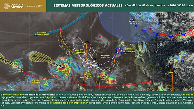
The SMN warning indicates that the Mexican thunderstorm and atmospheric instability will favor intense rainfall in the north. The agency warns that these conditions will be accompanied by electrical activity, wind, and possible hail.
- Sonora: 50 to 75 millimeters in the northern and southern areas.
- Chihuahua: 50 to 75 millimeters in the western and southern areas.
- Durango: 50 to 75 millimeters in the western and northern areas.
- Zacatecas: 50 to 75 millimeters in the western and southern areas.
- Sinaloa: 50 to 75 millimeters in the northern and central areas.
- Nayarit: 50 to 75 millimeters in the northern and southern areas.
- Baja California Sur: up to 150 millimeters in the central and southern areas.
The SMN’s rainfall forecast also includes very heavy rain in Jalisco, Guerrero, Oaxaca, and Chiapas, as well as heavy rainfall in Nuevo León, Guanajuato, Querétaro, Hidalgo, Puebla, State of Mexico, Veracruz, Tabasco, Campeche, and Yucatán.
Chihuahua and Sonora still have areas affected by water shortages
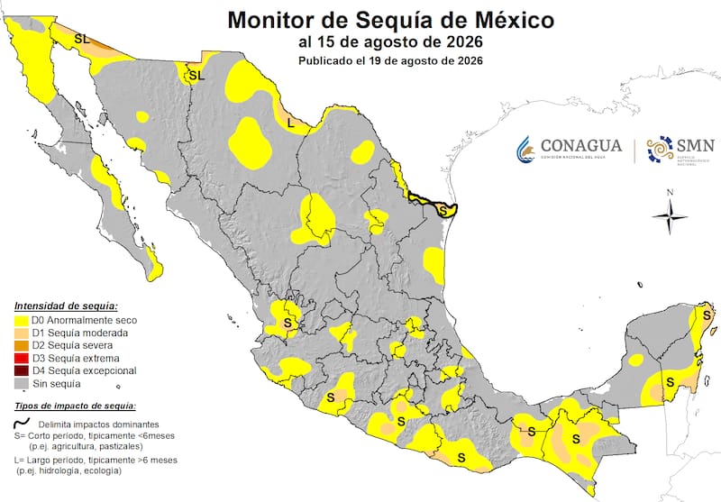
The August 15 report showed that Chihuahua was one of the northern states with the largest affected area. Some 25.8% had abnormally dry conditions, 2.4% had moderate drought conditions, and 0.1% had severe conditions.
The groundwater level showed 14.4% of the area under abnormally dry conditions, 5.6% under moderate conditions, and 0.9% under severe conditions. In Chihuahua, there are also five municipalities in that category.
In Durango, the municipal outlook was different: the monitoring system recorded some municipalities experiencing drought, although 9.9% of its surface area was under abnormally dry conditions. Therefore, rainfall can help restore moisture in certain areas.
The national outlook was also relatively consistent. In August, drought-affected areas were eliminated in Chiapas, Quintana Roo, Baja California, and Guerrero, while other states recorded considerably smaller affected areas.
How can you benefit from rainwater?
The importance of this rainfall lies in the fact that it can provide moisture to areas suffering from drought. The benefit will be greater where rainfall penetrates the soil and replenishes ditches, streams, or bodies of water.
In Chihuahua and Sonora, where the August monitor showed the presence of rainfall, the forecast precipitation could temporarily improve moisture conditions. In Durango, it could also benefit areas that remain abnormally dry.
The SMN itself indicates that flooding can “increase the levels of rivers and streams,” a sign that some of the water can become incorporated into shallow water systems.
However, there is an important contrast: an intense downpour does not necessarily mean a complete recovery of water flow. The SMN warns that rainfall can also cause flooding, landslides, and rising water levels in rivers and streams.
Rain will also affect other areas with drought conditions
The water will not only reach Chihuahua, Sonora, and Durango. The forecast includes significant rainfall in other states that also had areas affected by the climatic conditions recorded in the report corresponding to August 15.
In areas where the situation involving drought and previous flooding is particularly relevant:
- Guerrero and Oaxaca, with very heavy rainfall.
- Nayarit and Jalisco, with very intense rainfall.
- Zacatecas, with very heavy rainfall.
- Chiapas is also expected to receive very intense rainfall.
- Tabasco, Veracruz, and Yucatán, with heavy rainfall in specific areas.
The SMN forecast, issued at 6:00 a.m. on this date, still anticipates changes in conditions. The next update was scheduled for 6:00 p.m., or earlier if a significant change occurred.
In other words, the rainfall represents an opportunity for recovery for several areas that had been experiencing drought conditions, but it is still too early to speak of a widespread end to the situation. The impact will depend on the magnitude, concentration, and evolution of the rainfall over the coming weeks.
Source: cronista