

The Mexican National Meteorological Service estimates that the La Niña phenomenon will reach the country between June and August
The heat waves that have been recorded in recent weeks in Mexico will be followed by the effects of the La Niña phenomenon, which is a climatic event characterized by the large-scale cooling of the sea surface in the equatorial Pacific. It is the counterpart of the El Niño phenomenon and, like it, has the ability to cause alterations in the global climate.
According to the World Meteorological Organization (WMO), the effects of each La Niña event can vary in intensity, duration and time of year in which they develop. However, especially in tropical regions, La Niña produces climatic impacts opposite to those of El Niño.
When will the La Niña phenomenon reach Mexico?
The National Meteorological Service of Mexico (SMN) issued a warning in which it reported that there is a 49% probability that the La Niña phenomenon will develop in the country between June and August. The probabilities increase to 69% for the season between July and September.
Currently, at least until the most recent SMN report, dated June 11, the Mexican territory is under the effects of the El Niño phenomenon, which is characterized in the country by causing drought during the summer.
Although both phenomena are natural and cyclical, the World Meteorological Organization has warned that they now take place in the context of the climate emergency, which is increasing global temperatures and affecting seasonal rainfall and temperature patterns.
This 2024, La Niña will develop after nine years in which the highest temperatures have been recorded, according to the organization. “Our climate will continue to be more extreme (…) Therefore, the Early Warning initiative remains the highest priority. Seasonal forecasts for El Niño and La Niña, as well as the anticipated impacts on global weather patterns, are an important tool for reporting,” said Ko Barrett, climate policy expert and leader of the WMO delegation at the United Nations Climate Change session.
What will be the effects of La Niña?
The La Niña phenomenon is mainly characterized by a colder climate. It has also been observed that it increases the probability of extreme weather events, such as hurricanes in the Atlantic and droughts in parts of South America.
According to the climate updates of the world organization, the predictions for La Niña in 2024 include the typical effects: above-normal rainfall in the far north of South America, Central America, the Caribbean, the north of the Horn of Africa and the Sahel, parts of southwest Asia and the center of the maritime archipelago.
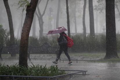
Therefore, intense rainfall is expected in Mexico. In its forecasts for this year, the National Water Commission has estimated that the rainy season, cyclones and hurricanes in 2024 will be more active than the previous year due to the influence of La Niña. Authorities expect between 15 to 18 tropical cyclones for the Pacific, which is in line with the historical average; However, in the Atlantic, the formation of between 20 and 23 cyclones is expected, an increase of 50%.
Christian Domínguez, meteorologist and researcher at the Institute of Atmospheric Sciences and Climate Change at UNAM, explained that “La Niña, which causes very cold surface temperatures in the Pacific, changes climate patterns globally and favors the formation of more tropical cyclones in the Atlantic.”
Source: elpaís


