
What states in Mexico will feel the effects of the new rainy season?
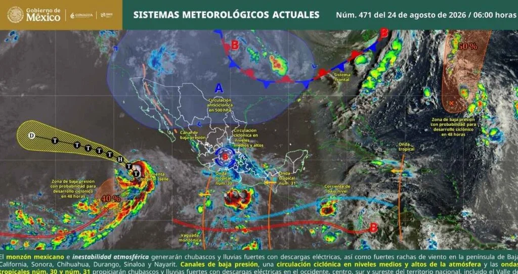
Various weather systems are converging over Mexico, creating a contrasting scenario: significant downpours in the central Pacific, central, and southern regions, along with extremely high temperatures in the northern border states.
The movement of Tropical Waves 30 and 31, combined with moisture from the monsoon in the northwest and internal low-pressure channels, will maintain conditions favorable for storms and strong winds throughout the day. How will the new rainy period affect the states of Mexico today, August 24?
Weather forecast: Mexican states under alert for heavy rainfall
- Heavy rainfall (50 to 75 mm): Southern Nayarit, central and western Jalisco, Colima, and northern and western Michoacán.
- Heavy showers with thunderstorms (25 to 50 mm): Areas of Sonora, Durango, Sinaloa, Guanajuato, Querétaro, Hidalgo, State of Mexico, Mexico City, Morelos, Tlaxcala, Puebla, Guerrero, Veracruz, Oaxaca, Chiapas, and Yucatán.
- Moderate showers (5 to 25 mm): Both states of the Baja California Peninsula, Chihuahua, Tamaulipas, San Luis Potosí, Aguascalientes, Zacatecas, Tabasco, Campeche, and Quintana Roo.
- Scattered drizzle (0.1 to 5 mm): Areas of Nuevo León.
Temperature conditions
- Above 45 °C: Extreme northeastern Baja California.
- 40 to 45 °C: Sonora, northern Sinaloa, northern Coahuila, east-central Nuevo León, and western Tamaulipas.
- 35 to 40 °C: Baja California Sur, Chihuahua, Durango, southern Zacatecas, San Luis Potosí, Guerrero, Morelos, Puebla, Veracruz, Oaxaca, Chiapas, and the entire Yucatán Peninsula.
- 30 to 35 °C: Nayarit, Jalisco, Colima, Michoacán, Aguascalientes, Hidalgo, State of Mexico, and Querétaro.
- Cold early mornings (0 to 5 °C): Mountain peaks and ranges of Durango, State of Mexico, Tlaxcala, and Puebla.
Wind gusts and coastal conditions
- Winds of 50 to 70 km/h: Isthmus of Tehuantepec (Oaxaca) and Campeche.
- Winds of 40 to 60 km/h: The entire northeast and north (Chihuahua, Durango, Coahuila, Nuevo León, Tamaulipas), northern central plateau (San Luis Potosí, Aguascalientes, Zacatecas), Nayarit, Jalisco, Tabasco, Yucatán, and Quintana Roo.
- Gusts of 30 to 50 km/h: Valley of Mexico, central Mexico, Baja California Peninsula, Sonora, Sinaloa, Veracruz, and Chiapas.
- Rough seas (2 to 3 meters): Western coast of Baja California Sur and the Gulf of Tehuantepec.
- Waves of 1 to 2 meters: Pacific coastline (Baja California, Sinaloa, Nayarit, Jalisco, Colima, Michoacán, and Guerrero).
Source: voxpopulinoticias