

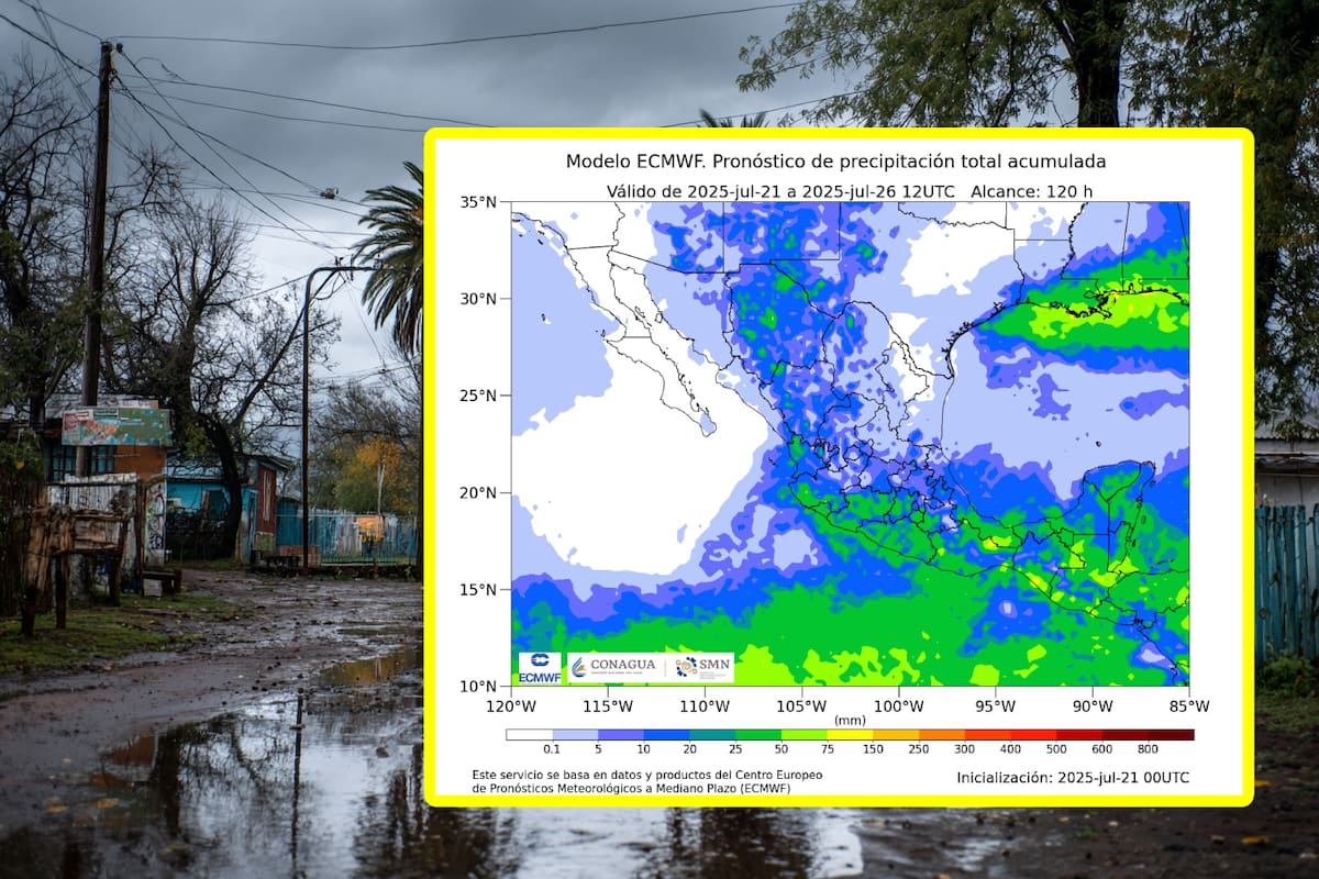
The National Meteorological Service (SMN), a Mexican government agency, has issued a detailed forecast for the next 72 to 96 hours, highlighting the areas most affected by the Mexican monsoon and the expectation of heavy rains for Wednesday, Thursday, and Friday.
General Forecast:
The Mexican monsoon will continue to interact with an upper-level cyclonic circulation, generating a series of weather phenomena in various regions of the country. An increased probability of heavy to very heavy rains, accompanied by lightning, is expected in several states, especially on Wednesday and Thursday. Additionally, hot to extremely hot temperatures are forecast in some areas, with possible dust devils in arid regions.
Wednesday, July 23:
Very heavy rains with intense rainfall (75 to 150 mm):
Nayarit (central and southern): The cities of Tepic and Río Grande will be particularly vulnerable. Jalisco (west): The municipalities of Puerto Vallarta and San Patricio are critical areas.
Chiapas (east and south): The cities of Tapachula and Palenque are under alert.
Tabasco (central and east): Villahermosa and Comalcalco will face heavy rainfall.
Heavy rains with very heavy rainfall (50 to 75 mm):
Durango: The city of Durango could experience intense rains.
Sinaloa: Culiacán and Mazatlán will be impacted.
Colima: Manzanillo and Colima will face significant rainfall.
Michoacán: Zamora and Morelia are at risk.
Guerrero: Acapulco and Chilpancingo.
Puebla: Puebla and Atlixco.
Veracruz: Xalapa and Poza Rica.
Oaxaca: Oaxaca de Juárez and Juchitán.
Campeche: Campeche and Calkini.
Yucatán: Mérida and Cancún.
Showers with occasional heavy rain (25 to 50 mm):
Chihuahua: Ciudad Juárez and Chihuahua.
Coahuila: Saltillo and Torreón.
State of Mexico: Ecatepec and Naucalpan.
Morelos: Cuernavaca and Jiutepec.
Intervals of showers (5 to 25 mm):
Zacatecas, Guanajuato, Querétaro, Hidalgo, Mexico City, and Tlaxcala.
Isolated showers (0.1 to 5 mm):
Baja California Sur, Sonora, Nuevo León, Tamaulipas, San Luis Potosí, and Aguascalientes.
Wind:
Wind speeds of 30 to 40 km/h with gusts of 50 to 70 km/h: Oaxaca (Isthmus and Gulf of Tehuantepec).
Winds of 20 to 30 km/h (12.5 to 18.8 mph) with gusts of 40 to 60 km/h (25 to 37 mph): Sonora, Chihuahua, Coahuila, Nuevo León, Tamaulipas, Durango, Zacatecas, San Luis Potosí, Guanajuato, Querétaro, Hidalgo, Puebla, Tlaxcala, Chiapas, Tabasco, Campeche, and Yucatán; with possible dust storms in Baja California and Baja California Sur.
Waves:
Waves of 1.0 to 2.0 meters (3.3 to 6.8 feet) high in the Gulf of Tehuantepec.
Temperatures:
Maximum temperatures of 40 to 45°C (104 to 113°F): Baja California (northeast), Baja California Sur (central and southern), Sonora, Chihuahua (southwest), and Sinaloa (north and central).
Maximum temperatures of 35 to 40°C: Coahuila, Nuevo León, Tamaulipas, Durango, Nayarit, Jalisco, Colima, Michoacán, Guerrero, Oaxaca, Chiapas, Veracruz, Tabasco, Campeche, Yucatán, and Quintana Roo.
Maximum temperatures of 30 to 35°C: Zacatecas (south), San Luis Potosí, Querétaro, Hidalgo (north), Puebla (north and southwest), and Morelos.
Thursday, July 24:
Very heavy rains with intense rainfall (75 to 150 mm):
Michoacán (west): Zamora and Morelia.
Guerrero (center and east): Acapulco and Chilpancingo.
Oaxaca (west): Oaxaca de Juárez and Juchitán.
Heavy rain with very heavy rainfall (50 to 75 mm):
Chihuahua: Ciudad Juárez and Chihuahua.
Jalisco: Guadalajara and Puerto Vallarta.
Colima: Manzanillo and Colima.
Puebla: Puebla and Atlixco.
Veracruz: Xalapa and Poza Rica.
Chiapas: Tapachula and Palenque.
Tabasco: Villahermosa and Comalcalco.
Showers with heavy rainfall (25 to 50 mm):
Durango, Sinaloa, Nayarit, State of Mexico, Mexico City, Tlaxcala, Morelos, Campeche, Yucatán, and Quintana Roo.
Intervals of showers (5 to 25 mm):
Zacatecas, Guanajuato, Querétaro, and Hidalgo.
Isolated showers (0.1 to 5 mm):
Sonora, Coahuila, Nuevo León, Tamaulipas, San Luis Potosí, and Aguascalientes.
Wind:
Winds of 30 to 40 km/h with gusts of 50 to 70 km/h: Nuevo León and Tamaulipas.
Winds of 20 to 30 km/h with gusts of 40 to 60 km/h: Sonora, Chihuahua, Coahuila, Durango, Zacatecas, San Luis Potosí, Guanajuato, Querétaro, Hidalgo, Puebla, Tlaxcala, Oaxaca (Isthmus and Gulf of Tehuantepec), Chiapas, Tabasco, Campeche, and Yucatán; with possible dust storms in Baja California and Baja California Sur.
Temperatures:
High temperatures of 40 to 45°C: Baja California (northeast), Baja California Sur (central and southern), Sonora, Chihuahua (southwest and eastern), and Sinaloa (northern and central).
High temperatures of 35 to 40°C: Coahuila, Nuevo León, Tamaulipas, Durango, Nayarit, Jalisco, Colima, Michoacán, Hidalgo (northern), Guerrero, Oaxaca, Chiapas, Veracruz, Tabasco, Campeche, Yucatán, and Quintana Roo.
High temperatures of 30 to 35°C: Zacatecas (southern), San Luis Potosí, Querétaro, Puebla (northern and southwest), and Morelos.
Friday, July 25:
Heavy rain with very heavy rainfall (50 to 75 mm):
Jalisco, Colima, Michoacán, Guerrero, Oaxaca, Veracruz, Chiapas, Tabasco, Campeche, and Yucatán.
Showers with heavy rainfall (25 to 50 mm):
Chihuahua, Nuevo León, Tamaulipas, San Luis Potosí, Nayarit, Guanajuato, Querétaro, Hidalgo, State of Mexico, Mexico City, Tlaxcala, Morelos, Puebla, and Quintana Roo.
Intervals of showers (5 to 25 mm):
Durango, Sinaloa, and Zacatecas.
Isolated showers (0.1 to 5 mm):
Aguascalientes.
Wind:
Wind speeds of 30 to 40 km/h (18 to 25 mph) with gusts of 50 to 70 km/h (31 to 44 mph) and possible dust storms: Baja California and Baja California Sur.
Winds of 20 to 30 km/h (12.5 to 18.9 mph) with gusts of 40 to 60 km/h (25 to 37 mph): Sonora, Chihuahua, Coahuila, Nuevo León, Tamaulipas, San Luis Potosí, Durango, Zacatecas, Guanajuato, Querétaro, Hidalgo, Puebla, Tlaxcala, Oaxaca (Isthmus and Gulf of Tehuantepec), Chiapas, Tabasco, Campeche, and Yucatán.
Temperatures:
Maximum temperatures above 45°C (113°F): Sonora (south).
Maximum temperatures of 40 to 45°C (104 to 113°F): Baja California (northeast), Baja California Sur (central and southern), Chihuahua (southwest and eastern), and Sinaloa (northern and central).
Maximum temperatures of 35 to 40°C: Coahuila, Nuevo León, Tamaulipas, Durango, Nayarit, Jalisco, Colima, Michoacán, Hidalgo (north), Guerrero, Oaxaca, Chiapas, Veracruz, Tabasco, Campeche, Yucatán, and Quintana Roo.
Maximum temperatures of 30 to 35°C: Zacatecas (south), San Luis Potosí, Querétaro, Puebla (north and southwest), and Morelos.
Alerts and adverse effects:
The forecasted rains may be accompanied by lightning and hail.
River and stream levels are expected to rise, which may lead to landslides, flooding, and flooding in low-lying areas.
In arid regions, such as Baja California and Baja California Sur, caution is recommended due to possible dust storms.
In the Gulf of Tehuantepec, waves of 1.0 to 2.0 meters are expected.
Important: The general public is advised to stay informed about the development of these weather events and follow the recommendations of the relevant authorities.
Source: elimparcial


